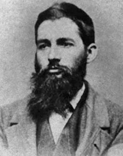
On March 26, 1862, three days after the Battle of Kernstown, Maj. Gen. Thomas J. “Stonewall” Jackson asked to see a 33-year-old schoolteacher in the Augusta County militia who happened to be good at drawing maps. After a brief conversation with Jedediah Hotchkiss on the cartography work he had done the previous year in western Virginia, Jackson launched the career of the most famous mapmaker of the Civil War with three sentences: “I want you to make me a map of the Valley, from Harper’s Ferry to Lexington, showing all the points of offense and defense in those places. Mr. Pendleton will give you orders for whatever outfit you want. Good morning, Sir.”
A native of Windsor, New York, Hotchkiss moved to the Shenandoah Valley of Virginia at age nineteen and worked as a teacher in the Mossy Creek Academy of Augusta County. Having a secondary interest in mining geology, Hotchkiss also took up the self-taught hobby of mapmaking.
Library of Congress
When Virginia seceded in 1861, Hotchkiss offered his services to the Confederate army, seeing his first action at the Battle of Rich Mountain in western Virginia. After a brief medical leave to recover from a bout of typhoid fever, Hotchkiss returned to the militia in 1862, seeking engineering duty but working initially as an adjutant. Although the Augusta County militia was officially mustered into the Confederate service in March 1862, Hotchkiss had yet to receive a commission before his meeting with Jackson on the 26th.
With his new orders to draw a map of the Valley, Hotchkiss began what he described as his “career as Topographical Engineer of the Valley District of the Department of Northern Virginia while that was Jackson’s command and then as Topographical Engineer, of the Second Corps of the Army of Northern Virginia, under the respective commands of Gens. Jackson, A.P. Hill, Ewell, and Early.”
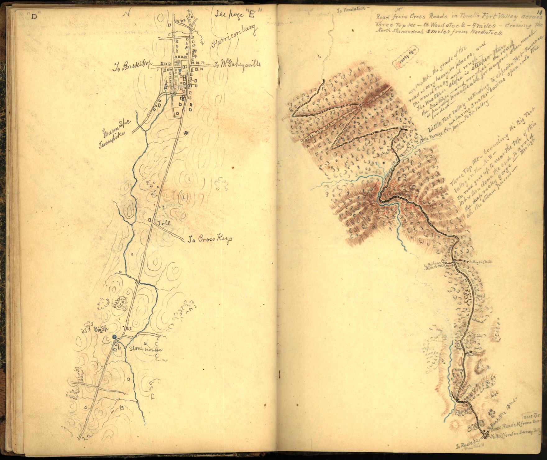
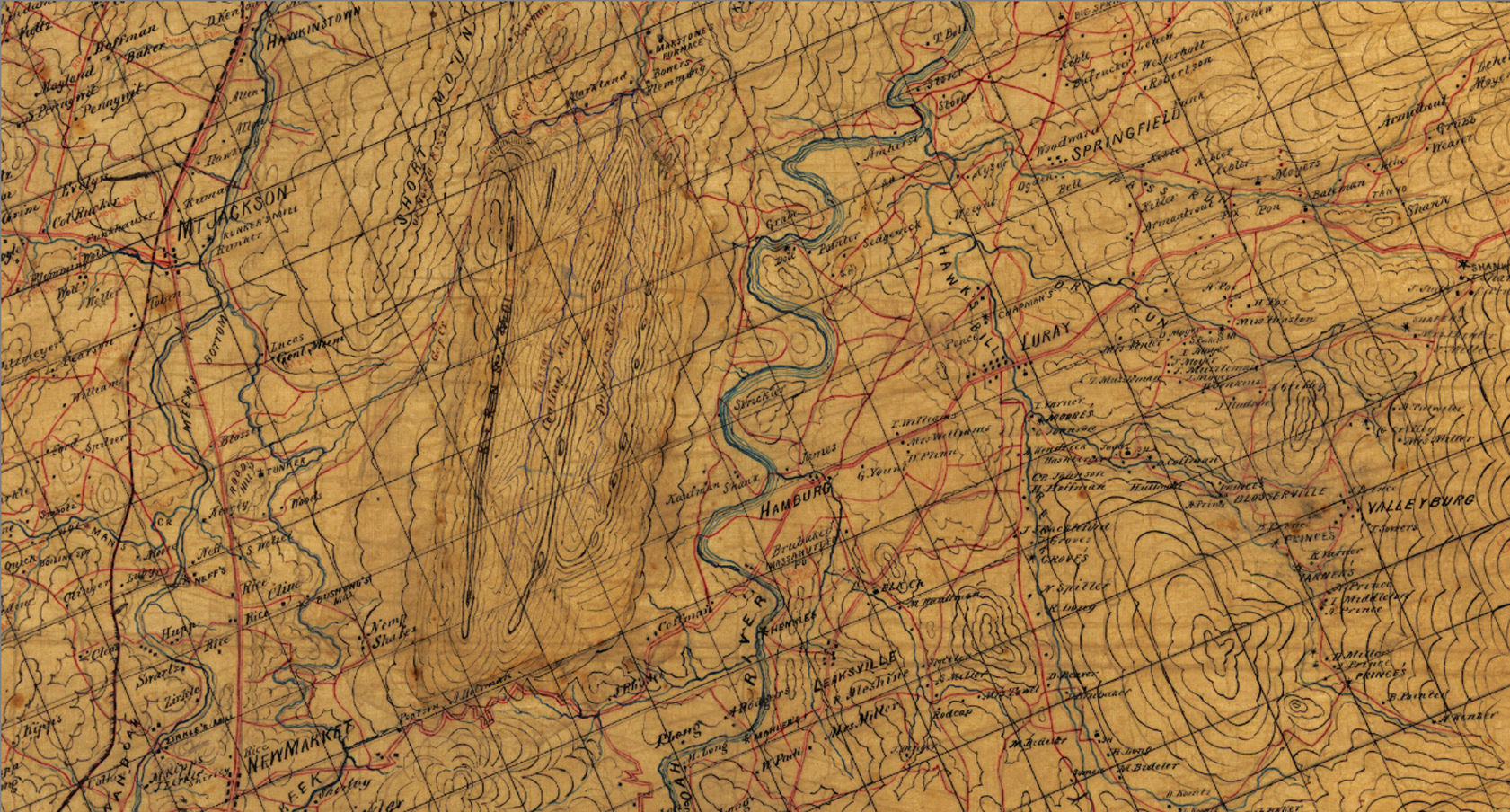
For the remainder of Stonewall Jackson’s successful Valley Campaign, Hotchkiss worked tirelessly in the field, performing reconnaissance while drawing topographical features in his sketch book, often from horseback. For greater clarity of detail, he used different-colored pencils – red for roads, blue for water, green for wooded areas, and brown for slope hachures. Hotchkiss’ highly accurate maps were a key factor in Jackson’s ability to evade, surprise, and defeat three separate Union armies in the Shenandoah.
When Jackson’s army left the Valley in late June 1862 to help in the defense of Richmond during the Seven Days Battles, Hotchkiss remained behind in his Staunton, Virginia, home working on his maps. He rejoined Jackson on July 19, 1862, prior to the Battle of Second Manassas the following August.
Jed Hotchkiss’ completed Shenandoah Valley map, preserved in the Library of Congress, is a masterpiece of detail and artistry. Completed in sections and drawn on tracing linen in a scale of 1:80,000, or slightly more than one mile per inch, the full map spans an impressive 8 feet x 3.5 feet.

Library of Congress, Geography and Map Division
Library of Congress, Geography and Map Division
Suggested Reading:
McDonald, Archie P., ed. Make Me a Map of the Valley: The Civil War Journal of Stonewall Jackson’s Topographer. Dallas: Southern Methodist University Press, 1973.


Leave a Reply